Menu
-
- Home
-
About Us
-
The Approach
-
Linking Language & Literacy
-
MindWing Learning
-
Learning Resources
-
SHOP
-
Blog
-
- About MindWing
- Our People
- Contact Us
- Your Account
- Login
-
Spain (EUR €)

The Importance Of Expository Text Comprehension In “Real Life” Situations
August 26, 2011 2 min read
After a TORNADO, an EARTHQUAKE and now a looming HURRICANE, at MindWing we have become preoccupied by the weather. Usually snowstorms are our biggest threat! The past couple of months of weather have been surreal. We have had workshops cancelled and have spoken to colleagues and friends throughout the east coast who have had school called off due to the hurricane warning.
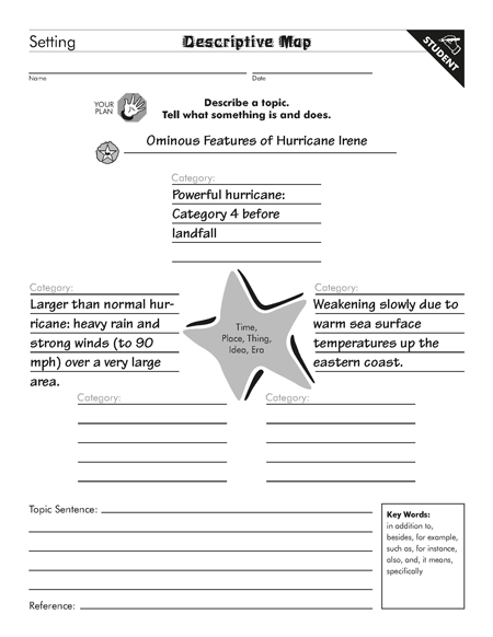
The paragraph below about Hurricane Irene was found yesterday on http://thesiweather.com/ and exemplifies the IMPORTANCE OF COMPREHENDING EXPOSITORY TEXT IN A “REAL LIFE” SITUATION. Below the paragraph are ThemeMaker® maps organizing the complex, extensive information from this weather report. We thought this could be used for a “content area” lesson.
HURRICANE IRENE
Despite the threat for severe thunderstorms later today and early tonight, the main story is the approach of dangerous Hurricane Irene. Irene continues to be a major threat to the Mid-Atlantic region for this weekend with numerous power outages and flooding problems likely. Irene appears to be headed on a collision course for the New York City metropolitan region and will likely create hurricane conditions Saturday night and Sunday to include torrential rains and destructive winds. Irene is headed for the Outer Banks region of North Carolina by late Saturday as a major hurricane (ie category 3 or higher). It should then move along the east coast to a position near New York City by Sunday night – likely as a category 1 hurricane. By early Monday, Irene will likely be moving towards western Massachusetts as a tropical storm. This storm has several ominous features that make it a very dangerous storm for the Mid-Atlantic and Northeast; especially, along the coast from North Carolina to Maine. First, it is a powerful hurricane - possibly reaching category 4 before making landfall on Saturday. Second, it is a larger-than-normal hurricane which means it will contain heavy rain and strong winds over a very large area. Third, and perhaps most important for New York and New England, it appears that this system will only slowly weaken as it rides up the east coast thanks in part to warm sea surface temperatures up the coast. All of this suggests an extreme weather event is in the offing near and along the coast from North Carolina to Maine and torrential rain and devastating winds will occur inland as well back to near the I-95 corridor. All of the major cities from DC to Boston will be impacted severely by Irene this weekend with the brunt of the storm here Saturday night and Sunday including possible wind gusts to 90 mph. Stay tuned for updates on this serious weather event for the Mid-Atlantic and Northeast.
See ThemeMaker® Maps below….


Leave a comment.
Comments will be approved before showing up.
